If you're not familiar with DailyMile, it's the social media version of an athletic training log, which not only allows you to keep track of your training, but also interact with like-minded folks at all levels. I've met a lot of wonderful folks through the site, it's been a huge help in getting my training back on track through the move. I expect to be writing about the site and my running more often here; I haven't really dug into it but it's an important enough part of my life that I shouldn't be avoiding it. If you have any questions about the site, feel free to ask me, I can either answer them or or put you in touch with someone who can. If you join, add me as a friend!
So now that I'm done with the plug, here's the story...
I left the house completely ignorant of what I'd find that day. I knew the peak of Mt. Yumihari was a popular park with fantastic views of Sasebo and the Kujukushima Islands; I knew the sign at the nearby intersection said it was less than 5k distance; and I knew it was a gorgeous day to do something outside with Theo and I dare not pass it up. All the information I'd found about it in English was about driving up, but what fun would that be?
So I loaded Theo in the backpack carrier, threw in a camera, bottles of water and a bunch of dried fruit, and figured I'd see how far I could make it before I was shut down by weather, kiddo or my own legs.
I was hoping to find some trails intersecting the road -- the hills around here are criss-crossed with undocumented walking routes known only to the people who live there -- but at least from the direction of my house, there were none. As steep as the switchbacks on the road became, any path crossing them would've been straight up anyway. So it was steep road all the way. Luckily there isn't much up this road so cars were few and far between.
I don't know if the folks who did see me were thinking "Impressive!" or "Fool!" The road was surrounded on both sides by dense forest and I think I saw a sign warning of bears at one point; I don't think my sunscreen got much of a workout.
Garmin says I made it the 3 miles of road (and 1150 feet of elevation gain) to the observation deck near the peak in just over 1 hour. Heart was pounding hard a few times. Wish I'd remembered to add my extra 50ish pounds of extra weight to the Garmin's calculations.
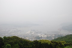
The heavy humidity and mist obscured most of the distant views, but there was still a lot to see. The humidity was so high, I was soaked with sweat from head to toe and wringing out my shirt. At the deck Theo and I rested, ate a snack, took pictures and explored the area of the peak for a bit over an hour before I decided to head back down.
I did find what appeared to be a trail down; but it was so steep & covered in wet leaves and mud that I didn't want to risk it with Theo on my back in less-than-ideal shoes. Next time, ne?
The walk down was much slower than the walk up, since I was already tired. A bit more than a mile from the house we reached a point where there was sidewalk all the way home, so I took Theo out of the backpack so he could walk the rest of the way and make things easier on Dad, slowing us down even more. Garmin says we were stopped about 37 min. of the recorded time.
It was a wonderful morning that definitely helped me relax and feel more comfortable in Japan...


No comments:
Post a Comment